


Boyds Voting District, Ferry County, Washington
About
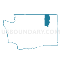
Outline

Summary
| Unique Area Identifier | 684151 |
| Name | Boyds Voting District |
| County | Ferry County |
| State | Washington |
| Area (square miles) | 68.41 |
| Land Area (square miles) | 68.26 |
| Water Area (square miles) | 0.16 |
| % of Land Area | 99.77 |
| % of Water Area | 0.23 |
| Latitude of the Internal Point | 48.71734600 |
| Longtitude of the Internal Point | -118.27884430 |
Maps


Graphs
Select a template below for downloading or customizing gragh for Boyds Voting District, Ferry County, Washington


Neighbors
Neighoring Voting District (by Name) Neighboring Voting District on the Map
- Barstow Voting District, Ferry County, WA
- Copper Butte Voting District, Ferry County, WA
- Hoodoo Voting District, Ferry County, WA
- Kelly Hill Voting District, Stevens County, WA
- Sherman Voting District, Ferry County, WA
Top 10 Neighboring County Subdivision (by Population) Neighboring County Subdivision on the Map
- Kettle Falls CCD, Stevens County, WA (7,292)
- Republic CCD, Ferry County, WA (3,126)
- East Ferry CCD, Ferry County, WA (1,239)
Top 10 Neighboring Place (by Population) Neighboring Place on the Map
Top 10 Neighboring Unified School District (by Population) Neighboring Unified School District on the Map
- Kettle Falls School District, WA (5,385)
- Republic School District, WA (3,288)
- Orient School District, WA (879)
Top 10 Neighboring State Legislative District Lower Chamber (by Population) Neighboring State Legislative District Lower Chamber on the Map
Top 10 Neighboring State Legislative District Upper Chamber (by Population) Neighboring State Legislative District Upper Chamber on the Map
Top 10 Neighboring 111th Congressional District (by Population) Neighboring 111th Congressional District on the Map
Top 10 Neighboring Census Tract (by Population) Neighboring Census Tract on the Map
- Census Tract 9501, Stevens County, WA (7,292)
- Census Tract 9702, Ferry County, WA (3,126)
- Census Tract 9701, Ferry County, WA (2,694)